
We three kings
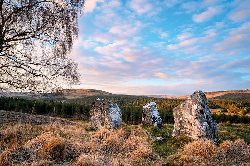
The Three Kings (photo: drphoto)
First published in edition 204 of The Northumbrian, Feb/Mar 2025
Through the two longest-named settlements in England and into a ruggedly lovely landscape, Anthony Toole explores the oddly little-known Redesdale Forest and Three Kings stone circle
The name seems ridiculously long, considering that there is little here beyond a farmhouse, a small car park, a toilet hut and a picnic bench. Yet Blakehopeburnhaugh is claimed to have the second longest place name in England, beaten only, by means of a single letter, by a tiny village less than a mile away. Reached by a detour from the A68 road between Otterburn and the Scottish border, its distinction lies in its position as the start of the scenically beautiful but rough-surfaced 12 mile Forest Drive to Kielder.
Our aim, however, was much less ambitious. Starting in late morning, after an hour’s journey from Newcastle, we took the signposted Three Kings route out of the car park, through a relatively recent deciduous plantation surrounded by mature conifers. Bluebells and stitchwort grew in profusion, with a scattering of mayflowers, to either side of the track. Small but dense patches of marsh marigolds and water avens hung over the side of a drainage channel into which a brown stream trickled from the hillside. A luxuriant growth of lichen covered a huge boulder. Numerous peacock, orange tip and small white butterflies chased each other above the verges.
After a short distance, we turned past a gate onto a second forest road that ran above the west bank of the River Rede. This took us to a junction beyond which the hillside had been clear felled of its trees, opening a view across the valley to the tiny settlement of Cottonshopeburnfoot. Seeming to consist largely of holiday caravan accommodation, this was claimed as having the only name in the country to beat its neighbour’s in length, provided it was written as a single word, as on the Ordnance Survey map.
We turned left and ascended gently to a point from which a narrow footpath ran off to the right, more steeply up the hillside. We were accompanied by a strong but pleasant breeze that shook the spring growth of cotton grass and bilberry, and the persistent call of a cuckoo from somewhere in the still standing part of the forest above us. The path levelled out and came to an end at a tall birch tree, which would have been completely hidden before the felling of the forest. Now, it stood alone over the stone circle we had come to see.
Rather misnamed, this circle consisted of four large stones, one of which had fallen over and lay flush with the surrounding grass, making it a ‘four poster’ of a type more common in Scotland. The three standing stones, according to local legend, are said to represent three un-named Danish kings who died here in battle. Excavations carried out here in 1971, however, revealed that the site was used for the burial of an important person during the Bronze Age, some 3,500 years ago. The grave had since been robbed of anything of value, and all that remained on its excavation were a flint tool and traces of carbon, possibly from a cremation.
While the forest surrounded the site, it would have been well-hidden. Now that the trees were gone, it was clear that the circle had been constructed where it would have commanded a view over the entire valley. Indeed, this now extended across the Rede and beyond the hamlet with the longest name to the hills of the Scottish border.
We retraced our route back to the car park. It was still early afternoon. After a light lunch at the picnic bench, we walked along the Forest Drive for no more than a few hundred metres, across a bridge over Blakehope Burn and past the farmhouse that is, in fact, Blakehopeburnhaugh. A sign pointing to Hindhope Linn drew us into the forest and along a narrow footpath through tall conifers contouring around the increasingly steep hillside that sloped down to the rushing stream in the valley bottom. After 10 minutes, we reached a set of steps that brought us down to the bank of the stream, and following a short turn to the left, we arrived at the waterfall.
Pretty rather than spectacular, the somewhat secretive Hindhope Linn was hidden even over the short distance from the top of the steps. It flowed in a thin stream over a rock slab, then fell freely between overhanging mats of grass, moss and bilberry into a dark brown, peat-stained plunge pool. To the right of the main stream, a pencil-thin trickle found a parallel path into the pool. Flowers that I later found to be pink purslane grew in abundance up the hillside.
After a few minutes admiring the cascade, we descended to the base of the steps, crossed a footbridge to the opposite bank, and followed the continuation path through the forest. Several mature conifers lay on their sides, having been uprooted by storm Arwen that devastated many woodlands in November 2021. The track was steep in places, and where it levelled out was caked with semi-dried mud. Carpets of wood sorrel lay on either side of the path, which led us to a point just above the top of the waterfall. From there, we followed our earlier route back to the car park.
This remote, small patch of Northumberland at the edge of the Redesdale Forest seems to be little-known, despite its proximity to one of the main roads into Scotland. Though we had enjoyed our walks on a warm, spring weekend, we shared them with few others. While we met perhaps half-a-dozen people on our short excursion to the waterfall, we saw no one else while visiting the Three Kings. On our drive to re-join the A68 road, we glanced across to the west. Prominent on the skyline stood the lone birch tree that guarded the site of those great stones.