
Aln another thing...
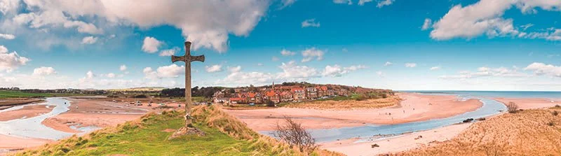
St Cuthbert’s Cross overlooking Alnmouth and the point where the Aln meets the sea
First published in edition 204 of The Northumbrian, Feb/Mar 2025
John Grundy follows the route of the diminutive River Aln, which though it may be small, follows the trajectory of major events which have set the course of history in the region
The bottom south-east corner of The Cheviots, where the hills peter out into the surrounding plain is…erm, what’s the word I’m looking for? What word would a proper writer choose? Erm... nice, I think that’s the word I was looking for, and it is nice to look at and equally nice to look from. But the word is pitifully inadequate because in fact this is a landscape of extraordinary views.
There are two rivers which emerge from the hills just a few miles from each other in this little area. They are the Aln and the Breamish, and even though they have come from the same hills, started their lives no more than a few miles from each other, and hit the plains so close together, they set off towards the sea in entirely different directions.
Isn’t that a remarkable thing? The Breamish heads north past Wooler to join the Tweed, while the Aln sets off pretty well due east towards Alnwick before reaching the sea under its own steam at Alnmouth.
In recent years, I have found myself drawn towards both rivers quite often in these pages. The Breamish, in fact, very often. But the lower reaches of the Aln have started to appear more recently when I have been writing stories about Alnwick and Alnmouth. I have written about the magnificent landscape and architecture of Hulne Gardens through which the river makes its way, and the truly amazing Edlingham Castle, which I featured in a recent article, is high on a hillside looking down on the Aln. But so far I appear to have largely ignored what happens to the river upstream from there. However, I’m going to pay attention to it now.
You’ll be thinking, with all of these mentions of splendid places and talk of upstream and downstream, that the Aln is a mighty river, not unlike the Mississippi or the Nile, but in fact my research (a quick glance at Wikipedia, I have to admit) reveals that the whole river, from source to sea, is only about 16 miles long and barely enough to be called a river in many places. Even in Northumberland it may be the minnow among the streams dignified by the title “river”. I imagine, though I haven’t checked it, that there are little streams called burns which are almost as long, but as they say, “size isn’t everything” and the Aln, in lots of ways, punches well above its weight.
It rises in the hills just above and a couple of miles west of the village of Alnham in one of the wildest, bleakest and least-populated areas of Northumberland, and that’s saying something. It is even less populated than the rest of The Cheviots. My research (Wikipedia again, I’m afraid) reveals that Northumberland as a whole has a population density of about 63 people per square kilometre, while the parish of Alnham has a measly 26.
This wildness and emptiness is thrilling, and I have loved it since I first went there 40 years ago as a listed building fieldworker. In that role I drove up an extremely steep road past the parish church in search of listable buildings, but found none. I found no buildings at all, in fact, just vast solitude and a single-track road winding over the moors.
The large-scale maps I carried revealed that the substantial boulder protruding to the right of the road was called The Grey Yade of Coppeth and a narrow section of the Coppeth Burn in the valley below was The Devil’s Leap. The map revealed that I was driving past a whole range of prehistoric settlements.
All of these things were stirring to the imagination, but there was nothing recent or visible for about 3 miles until I reached the end of the road at Ewartly Shank, which was as lonely a homestead as I have ever visited. As a romantic explorer, I loved it; as an inveterate and timid little townie I was appalled by the thought of living there amid all that loneliness and thousands of terrifying sheep.
At the time, in the 1980s, I was told a story which has since become much better known and which revealed the dark possibilities of our local hills. On November 17, 1962, two shepherds who lived at Ewartly Shank were returning in wild winter weather from Rothbury Mart. In their sensible way, they were travelling by tractor and must have known the hills as only shepherds can, but they never made it. Their names were Jack Stott and Willie Middlemass and their bodies were found the following day, buried in snow, less than half a mile from home. A few years later, their deaths led to the foundation of the Cheviots Mountain Rescue Team and in 2007 a cairn and memorial was built to mark the place where their bodies had been found.
In their memory, I’d like to add a little memorial of my own – a fragment of a poem by the Edwardian poet Wilfrid Gibson, who came from Hexham. Gibson wrote about another northern shepherd called Anthony Earnshaw who was also found dead in the snow, surrounded by his sheep:
We found him sleeping in the drifted snow,
Beside his buried and still breathing ewes,
‘Tis rarely granted any man, to know,
And find unsaught, the death that he would choose,
Yet he who’d always laboured among sheep,
Since he could walk, and who had often said,
That death should find him working, stumbled dead,
Succouring his flocks and by them fell asleep.
A couple of years after my first visit to this memorable spot I returned in a different role. While making a film about prehistoric Northumberland we shot a scene at Castle Hill, which lies just to the left of the road I have been describing. At the top of the hill is an Iron Age hill fort, a multivallate fort, no less, which means that it has a series of deep vallums, or ditches, protecting the interior. It is a tremendous survival in a tremendous spot, high on a promontory overlooking the valley of the Aln far below. As was my wont in those days, I had dressed up as an Iron Age warrior and pretended to attack the fort. I Imagine that I looked like a bit of a plank and it’s no surprise that the television critic of the local paper was less than impressed by my performance, writing: “Memo to the producer of Grundy Goes, there are people who dress up and pretend to be other people; they are called actors…”
Fortunately, the excellent photo of the hill fort provided by my friend Tim Watkinson doesn’t include me lightly clad in woad, but does justice instead to the wild beauty of the landscape.
From their promontory those prehistoric folk would have almost certainly looked down on a wooded valley, and this is a rich mixture of woods and fertile pasture still, an extraordinary contrast to the wild and treeless fastnesses above it. I’m sure they must have loved it, those ancient residents – the river rich in fish with plentiful water for their increasingly domesticated livestock, the woods a source of hazelnuts and other vegetable options. People have loved it ever since and it has become littered with desirable places to live. The main village of Whittingham is delightful and surrounding it is a quite impressive crop of country houses. There is the magnificent Callaly Castle (part of which is currently for sale if you’re looking for the country gent’s elegant life), and the beautiful early 18th century Eslington Park (the east wing of which is an equally elegant 5-bedroom holiday let). I find myself itching to talk about all these places, not to mention Lorbottle Hall, at one time the home of the late fashion designer Jean Muir, inventor, I believe, of the little black dress (and who would want to be without one of those?).
I might have to beg permission to return with a sort of chapter two about the Aln, which is, as I’ve said, not a long river, or a mighty one, but it is pretty enough to bring pleasure whenever it is spotted and big enough to have been the scene of many significant events. More than 2,000 years ago, the Romans built a fort on its south bank at Learchild a little upstream from Edlingham, to protect a crossing of the river on their road to Berwick.
In Anglo-Saxon times, Whittingham church may well have been the scene of momentous events when Guthred from that village became leader of the invading Danish army and made peace with the monks of Lindisfarne. It also seems that Cuthbert himself was declared Bishop of Hexham there. After the Norman invasion, the river became a sort of rather diminutive border between England and Scotland and two battles between the two countries took place on its banks. One of them, on November 13, 1073, led to the death of the Scottish King Malcolm III. At the other, a century later in 1174, another Scottish king, William the Lion, was captured, imprisoned and eventually ransomed before retaining his crown.
War and violence continued throughout the Middle Ages and well into the 1600s, and I tried to calculate how many castles and towers, bastlehouses and strong houses line or lined the river’s banks, but I ran out of fingers and toes and had to give up (though I was struck by the ‘ancient tower’ in the middle of Whittingham where an inscription records that it was “formerly used by the village in times of rapine and insecurity.”)
Well, there’s not a lot of rapine or insecurity along the Aln nowadays. It’s a peaceful place, a pretty place, a little place even; but packed, as so many little things are, with interest and excitement. Give it my love if you happen to spot it.