
Within these walls

The Bondgate is the last remaing entrance through the town walls
First published in edition 204 of The Northumbrian, Feb/Mar 2025
Alnwick’s medieval town walls have long since vanished. Or have they? Steve Newman takes a walk around town to explore the ghosts of the walls that once enclosed it.
The only towns in Northumberland to be enclosed by medieval walls were Berwick and Alnwick, which is surprising when you consider how often Hexham was raided and burned by the Scots during the border wars.
The fact that Hexham had no town wall could well be put down to the cost of building. Indeed, there is some conjecture that Alnwick’s walls were not fully completed for this reason. Certainly, it took some 50 years to build the walls, problems experienced by the town burgesses in raising the funds possibly explaining why they took so long to complete.
A licence to build a defensive wall was granted in 1433 by Henry VI, and from 1452 £20 was received annually for the work, with additional permission from the Crown to raise money granted in 1472.
The walls may not be visible today, but their shadow is still traceable around the town; their foundations are still present in many places; and there are gardens which have surviving segments. We know this because these segments fit descriptions of the walls – some have a fire step for archers, while some feature Jacobean brickwork, newer than the blocks to which it is affixed, used as facing.
A survey of a garden in Hotspur Street found evidence of a glacis, suggesting that the walls survived long enough to be modified against artillery bombardment. Also in 2001, archaeological studies in Greenwell Road found a section of the wall running in a north-east to south-west direction. Found at a depth of about 3ft 6ins and about 5ft wide, it was constructed of squared sandstone blocks bonded with lime mortar.
It is thought the wall was around 6ft thick and 20ft 6ins high, and you can get a good idea of this by looking at the south western end of Bondgate Tower, where the scar of where the wall butted up against it is still visible. This is not to say that the walls were the same thickness all the way around. As the gates were the weakest point of the defences the wall may well have been taller and thicker here.
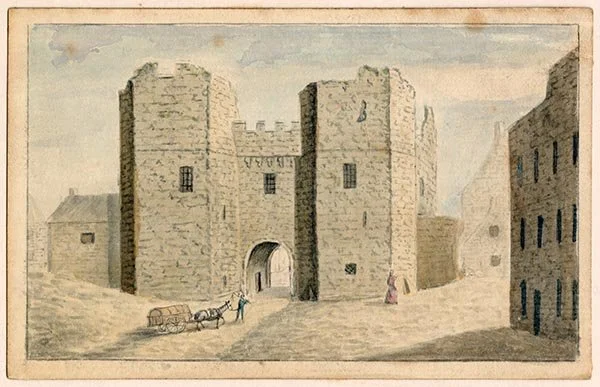
The Clayport Gate in 1773
The walls certainly left their mark on the town and it is still possible to follow most of its course on foot today, as many of the modern streets subsequently developed along the line of its course. This is probably because there would have been a defensive ditch in front of the walls and a path would have developed between the two. 17th century court records describe the line of Dispensary Street as a church path (to St Michael’s) along the old wall where it ran to the third known gate of Pottergate.
From Bondgate Tower, the walls ran along Hotspur Street, Green Bat, Tower Lane, Dispensary Street, and Northumberland Street. Before reaching Bailiffgate, it is thought that it turned towards the castle, but its actual course is uncertain and there may have been a connecting spur to the castle itself. It is thought that it then followed close to Greenwell Road, as mentioned earlier, and back to the Bondgate Tower.
There is conjecture about the number of gates through the wall. Robert Norton’s map of 1624 clearly shows three – Bondgate, Clayport Gate and Pottergate – while some scholars suggest there was a fourth at Narrowgate. This open to debate, though the first Ordnance Survey maps show it to be the site of a tower.
Clayport Tower formed the west gate. It was to the south of the present bus station and butted up against the site of the present Working Men’s Club. It was similar in design, but higher by one storey than Bondgate Tower. It was demolished in 1804 but its site is still shown on Wood’s town plan of 1827. The watercolour of the tower painted in 1733 shown opposite is part of the Northumberland Estate Archive Collection.
The present Pottergate Tower was built in 1768 and is thought to lie on the site of the earlier tower, though this remains contentious. But the fact that its orientation is not north-south but angled to the north-east would suggest it was as this follows the curve of the wall. Tomlinson noted in 1888 that “a considerable length of the town wall” continued north from the present location of Pottergate Tower and along Northumberland Street, adding that it survived to “five feet in height, with the remains of a corner tower.”
The only remaining gate is Bondgate Tower, which some still refer to as Hotspur Tower, which acted as the eastern gate through the walls. Built after 1434 (circa 1450) by the Earl of Northumberland, it is surprisingly not crenelated and again is clearly shown on Norton’s 1624 map. It is polygonal on each side and on its east face with its narrow lookout slits there are the remains of large corbels in the centre. As these are directly above the archway they were probably to support machicolations used for dropping rocks, boiling water and the like on any attacking force below.
The panel below has a faded Percy lion rampant by a sculptor named Matthew, which is surprising in itself as at this time most arms carved on gateways represented the town itself rather than the dominating family. There is a portcullis groove to the outer arch and, as stated earlier, the scar of the town wall is clearly visible on the south western side.
So, the walls may not be visible at the moment but they are still with us, maybe not in sight, but their influence and shadow will be here for a long time hence.
The author is indebted to the following for their assistance in researching this article: The Archives of the Duke of Northumberland; Nick Lewis; Alnwick Civic Society; Alnwick Local History Society; Sheila Amaria